An Ultimate Guide to Solo Trekking the Cordillera Huayhuash, Peru
- Feb 4
- 23 min read
Updated: Feb 25
What does this musician do when he's on holiday???
Explore my memories of the Cordillera Huayhuash Trek in Peru
I absolutely love my work as a full-time musician in New Zealand; the ability to do what I love, to create original and cover material that fits my unique style and voice, to create memorable experiences for individuals, couples and groups every weekend! I consider myself extremely lucky.

Another amazing perk of this job is the ability to create my own work schedule, and when the NZ Winter rolls around, things usually become a little more quiet on the wedding and private event side of things.
So, why not block out some time to explore the world?
I have a travel guitar and it's honestly a huge luxury to play music and sing without any agenda / the need to 'rehearse' or be at venues every weekend. I feel the pure music passion return when I play just for me.
In 2024 (Oct/Nov) I explored Sri Lanka, Nepal and Southern India.
In 2025 (July/Aug/Sept), I decided to explore South American - specifically, Peru, Argentina, Uruguay and Brazil (it's a huge continent!).
And, one of the best ways to start a decent adventure like this, is to start with a trek in the mountains! Really get some perspective on life and be humbled.
Here's an ultimate guide to solo trekking the Cordillera Huayhuash in Peru.
Cordillera Huayhuash Trek
Starting Date - Saturday, 12th July 2025
Complete Date - Saturday, 19th July 2025
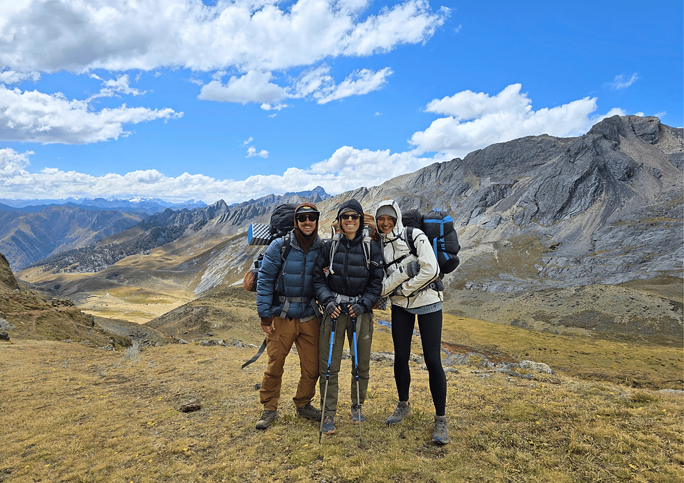
I did this with my partner Katie, and we enjoyed absolutely perfect weather for it! Technically 'Winter' in Peru, but from May to September it is known to be the 'Andean Summer', which typically includes blue skies and sunny days, with limited rain.
We experienced a brief moment of hail (for about 15minutes) on the last day of the trek, and that's it!
An Ultimate Guide to Solo Trekking the Cordillera Huayhuash, Peru
The Cordillera Huayhuash trek is a premier, high-altitude 10–12 day, 120-135km circuit in Northern Peru, often ranked among the world's best, featuring close-up views of jagged 6,000m+ peaks (like Yerupajá), turquoise lakes, and 8+ strenuous passes over 4,500m. It is a remote, challenging hike starting in Llamac, best done from May to September.

Should I Go Guided, or Unguided?
It's a super challenging hike; most friends I spoke to hired a guide and had help carrying their gear. I would say, unless you have a large appetite for heavy bags and super challenging uphill, high-altitude walking, then get a guide.
In saying that, I feel amazing after completing this solo; the sense of accomplishment is massive! It's very much doable, but you want to be organised.
Other Key Logistical Info:
LIMA TO HUARAZ - getting from Lima to Huaraz is easy - take an overnight bus; approx 8-10 hours. Get a seat that fully reclines so you can actually sleep!
HIRE GEAR IN HUARAZ - you can hire gear in Huaraz easily, go to this shop - Aupa Raju Hire Shop. We bought gas canisters, a map and hired a tent, sleeping pads and sleeping bags. All shops are similar price, but we felt these people were most friendly. They even gave us money back as we finished early.
FOOD - if you can, you're best to bring high-protein options from home. We used Radix, from NZ - worked out very well! There's not much of a selection in Huaraz, or Lima - but, you often find people selling excess freeze dried food supplies.
ACCOMMODATION in Huaraz is easy to find - we liked Huaraz Colonial Bed & Breakfast
ACCLIMATISE - you definitely need some time to acclimatise - there are lots of day walks you can do. We loved Laguna Churup - very accessible, not too far to drive in and out, and stunning laguna and high altitude (we had about 3 days total, with that day trip included before staring Huayhuash)
GPS MAPS - we used Cal Topo (we thankfully found out about this the night before leaving, and it was the best!). Free app - just make sure you find the trail, and your route and zoom in so you can see the map fully; that means you can still see it when you're offline. Cal Topo had both valley route and alpine routes marked.
LOCALS - dealing with locals; general rule, don't trust any pre-negotiated pick-ups, or arrangements until you're there doing it. We got left in the lurch a few times - beware. Everyone is friendly though, just a different way of doing business.
DAILY ITINERARY - you can use my info below for your daily itinerary. We also used Beyond Brooke - her website was super helpful!
PACKLIST - down at the very bottom - Packlist Here
~~ My Trip ~~
Totals for Trekking Cordillera Huayhuash in Peru
(6 Nights / 7 Days)
Total Elevation Gain - 4,670m (approx)
Total Distance Trekking - 101km (approx)
I first arrived in Peru on 8th July, with one day in Lima, then an overnight bus to Huarez - the bustling mountain town where you can find a tonne of day trips, the Santa Cruz trek, along with the Cordillera Huayhuash trek.
Huarez is sitting at 3,052m, so it's a fantastic base for these adventures (average sleeping elevation for Huayhuash is about 4,200m (with the Huayllapa Village being 3,500m).
I had one rest day in Huarez, then went for a day trip to Laguna Churup (4,450m) - a fairly gentle walk, but being my first proper hike in a few months (also at being back at altitude) it was challenging enough, even with a small back pack. The lake was super refreshing though!

The day after Churup, one more rest day, then it's straight onto the bus at 4.30am, leaving Huarez and heading to the Huayhuash start point, Cuartelwain (4,170m)
Here's what we packed (for two people). Full pack list items mentioned at the bottom.

Day 1 - Cuartelwain to Laguna Mitucocha
The first day will be tiring as you need to travel from Huarez to your starting point, which means an early rise, one of two bus / shuttle changes, multiple stops, bumpy roads and high chance of road work delays.
Overall, the day starts with a big climb up to the first pass, then the option of valley route or alpine route to the first campsite. Rolling hills and greenery, with a traversing decent to Laguna Mituchoca for our wild camping site near the cows, and next to a stream / water source.
Some key metrics from day one:
Time on Trail - 8 hours
Main Route or Alpine Circuit - Alpine (was a nice walk)
Elevation Gain - 685m
Total Distance - 9.1km
Highest Elevation - Cacananpunta at 4,690m
Campsite - wild camping at Laguna Mitucocha (4,200m)
Here's my personal blog of day one:
Starting with 4am wake up, then debarkle with pick up. Our arrangement was 430am pick up from our hostel, and the guy messaged us at 4am saying to walk 20 mins down the road. I didn't check my phone to 430, so was a stressful start, with only 4/5 hours sleep.
Bus was FREEEZING in the morning. Actual ice chest. Got a bit nicer when the sun came up, and they did give us blankets...
Stopped for a transfer, chatted with a girl from France and an older dutch couple - all doing it solo like us.
We stopped in Llamac for breaky; small, quiet mountain town. Drive on another hour to Cuartelwain for the start of the track.


Found three big tour groups on arrival, and we thanked our lucky stars that we were brave enough to tackle this adventure unguided.
Day started with a 600m.straight up over the first pass - outstanding valley views on both sides at the top. Had our lunch, empanada de pollo and eggs for lunch, and opted for the Alpine route over to Laguna Mituchoca.
Alpine route was just us, navigating the high line with Cal Topo App - life saver app!
There was a big sign at the start saying 600soles fine for going that way, but we heard it's fine.

Katie, Alice and I walking the high line, not a soul in site!
Was a really fun first day - vast valleys, staying high on the ridge and following cal topo and Katie's knowledge of the geography.
We dropped down by Laguna Mituchoca and set up camp. Just us! Radix meals, hot tea, everything working fine for us.
We saw the dutch couple arrive and was impressed they took that route also.

I was feeling a bit queasy - nerves from the start of the walk (what have I signed myself up for?!?), but also I think our lunch wasn't sitting well... Took a couple altitude pills and went to sleep. Felt rested and fine in the morning.
Had a couple of cows come get pretty close to our tents at night!
Eight hours solid on the trail. Decent day.
Day 2 - Laguna Mitucocha to Laguna Carhuacocha
Time on Trail - 8 hours (we took a slight detour)
Main Route or Alpine Circuit - Alpine (which is a pretty hairy route)
Elevation Gain - 715m
Total Distance - 9.1km
Highest Elevation - below Jirishanca chico 4,870m
Campsite - wild camping at Laguna Carchuacocha (4,138m)
Our Dutch friends decide to take the valley route, and Katie, Alice and I opt for the Alpine route again! We skip the camp fees - whoop! But, bit of a crazy story follows...

It's a super steep start, straight up, and then we come to a big valley, with one route kind of going down then up, and the other path staying quite high, sideling the mountain. We decide to stay high, add walking up hill with our bags sucks!
The traverse starts to get super steep, and slippery with rocks and scree, but we still see a bit if the path and are able to follow it.
We somehow go a bit off our Topo GPS map, and get a little bit too high, essentially trying to cut up the the top a bit to too early.
We climb up a few chimney moves as we see that's it's accessible to get up. But now we're committing to a new trail, and we don't really know if it's safe, or even possible, but going down is almost a little too risky too. Oh boy!
I make a call for the group to drop my bag and climb up to assess the terrain, see if it's possible and how dangerous it will be.
I start climbing, literally rock climbing, and thankfully for most parts it's not a sheer drop, but falling would very likely result in super bad injury or death. I climb through very narrow areas (thinking how the actual fuck can I do this with an 18kg behemoth of a bag on my back), I scramble, I think about turning back, I keep going - the top seems to be a mirage. I'm now out of shouting distance from the girls, and find myself literally in a rock climbing chimney move, which I can't actually make. The top is so close, but so far!! I'm scared, and thinking about turning back, but I'm so close!!! I gather myself, look around for an alternative route and see a scree ramp that I could scramble up. This one now has a vertical drop to death tho... But I ramp feels wide enough to be safe. I crawl up, and then up over a few little humps, still hands and feet, and make it to the top! Oh the relief - it's safe up here, I can see the path in the distance and there's enough space not to be dangerous.
But, my giant bag, and the girls with there bags are still way below!!!!!
The super steep ridge climb
The life and death, survival scramble to the top after deviating off path a bit....
The absolute elation of getting to the top; lunch time!

Long Walk out and camping out the back of the Laguna. Seeing the point we actually should have come up, which looked like a scary scramble, but easy as compared to what we did!
Went by a lake and took another dip. That's two 4500 lake swims now, and many more to come.
Option to take a high Alpine route toward camp, or gracefully decend - we took the more chill option and gradually came down.
Saw the main campsite which is always an eyesore out here. But we kept going and made camp at the complete opposite end of the laguna.

Making a fire and feeling blessed to be alive.
Eight hours solid on the trail. Bigger day than before, was getting dark ish when we arrived to set up camp.
Day 3 - Laguna Carhuacocha to Huayhuash via Silua Pass (Tres Lagunas)
A stunning day, visiting the Tres Lagunas - another huge uphill day with our heavy packs!
Time on Trail - 8 hours (with plenty of breaks)
Main Route or Alpine Circuit - Alpine Route (which is actually a main route via Tres Lagunas)
Elevation Gain - 820m
Total Distance - 14.8km
Highest Elevation - Silua Punta 4,830m
Campsite - official campsite at Huayhuash (4,350m)
Waking up with a cow right next to Alice's tent.
Pack down, and the absolute boggy walk across a paddock to the start of the trail.
In my big boots I managed to stay fairly dry (the girls had more trail shoes which were wet for sure), until we saw a little river with no way to pass except straight through. SOAKED! First 30mins of day two... Duck through a barbed wire fence, take shoes off, rinse out socks, and then get approached...
Getting approached and hassled by a local, asking us for money 'for the community'.
Alice spoke fluent Spanish which was helpful, but the guy was not budging, and at one point said, so how do we resolve this? Violence? Telling us we'd have to turn around and go back.
Side thoughts on the Huayhuash payment system - feels very scammy....
Anyway, we finally get going (after paying 60S instead of 90S), stunning, fairly chill trail winding along lake, all feeling good.
See the climb up and it looks gnarly, but here we are. Let's go!
Winding up along a valley, and we start to see the Lagunas. Stopping for snacks along the way.

Even though it's the Alpine route, it's the normal route for most groups, so people on the trail. No donkeys though, too steep and narrow for them.
Make it to the top (false summit - Siula Pass is around the corner and still another 200/300m climb!!!), but we had an amazing time at Tres Lagunas - magical vista!!! We made it. Fun photoshoot!
Continue around and see the trail of what we need to climb and our hearts sink. This trek is absolutely gruelling!!!!
At snails pace, we make it to the top; zig zagging up rock and rubble, at about 4,700m. But we finally make it, high fives and time to enjoy a big lunch with a brand new vista from the top.

Try to re coup some energy, and make our way all the way down to a cool lake and river. Katie swims, and we continue down to the Huayhuash campsite. It's actually super lame - noisey, dogs barking, some idiot near us has music playing till quite late....
They have toilets and running water, but honestly it's way nicer being away from the masses. We get approached by the wardens; two older ladies with a baby. 30 soles each... We don't fight this time as we're staying in the campsite. Only 'official' campsite we've stayed in all trip; called Huayhuash, so fitting to give it a go.
Early nights. In bed by 7pm, bundling up and trying to stay warm. Merino socks, long johns, top, mid layer, beanie and bundled into a -13 sleeping bag.

Another humungous day, the body is so sore and tired - our bags must be 17+ kg...
Anyways, ready to do it all again to tomorrow, day 4 approaches!!!
Day 4 - Huayhuash to Laguna Juraucocha via Trapesio Pass
Another big day on the trail; today we walk our way up to what I described as the half way point.
Reaching Trapesio Pass is definitely a feeling of accomplishment, with an incredible vista at the top, and the knowing that (for the most part) you're kinda walking out from there.
We continued to opt for the Alpine Route - so far, every day we've taken this option.
It is more challenging, but equally more remote and more of an adventure.
Getting up to the pass is the common route everyone will take, but at the top, you can veer off to the Alpine route - highly recommend this option on this day.

Time on Trail - 9 hours
Main Route or Alpine Circuit - Alpine - taking main route up to Trapesio, then alpine variation route to Laguna Juraucocha
Elevation Gain - 700m
Total Distance - 14km
Highest Elevation - Trapesio Punta 5,010m
Campsite - wild camping at Laguna Juraucocha (4,400m)
Katie was up at 5am ish (probably earlier as she couldn't sleep), making hot water and getting a jump on the day.
Previous days we've been up with the sun at 7am, leaving by 8.50am, always finding we were a bit time poor in the afternoon.
So up and at it, left camp by 7.30am which was great - gradual up hill, up the valley, then into the pass which was steep and grindy, just like the last three days!
Side note about how the guides left there campsite - coke bottles, plastic - disgraceful.
This time though, we were on trail with the rest of the masses and donkeys, which often time I don't mind. You can kinda float along with the group when it's like that.
We make our way to the top, and it's a freezing cold wind there, but epic view of a cool mountain and Laguna in the distance. We layer up, and walk a little higher to get some respite from the wind to have lunch.

Radix Shout Out!
A NZ based, high-performance and nutrient dense freeze-dried meals. We brought these over from NZ and were thankful we did. There is really nothing in the freeze dried category in Peru to fuel your trips, and when you're thinking of protein, you want something you can trust and rely on.
I highly recommend the Radix meals (breakfast, lunch/dinners) - Katie and I would have one meal each for breakfast, then share a pack for lunch, then one each for dinner. Snacks and protein bars in between. Lots of electrolytes and water.
Our path from here is off the beaten track - no donkeys and we didn't see a single person (on all the Alpine tracks we've walked (sans day 3), we haven't seen anyone!).
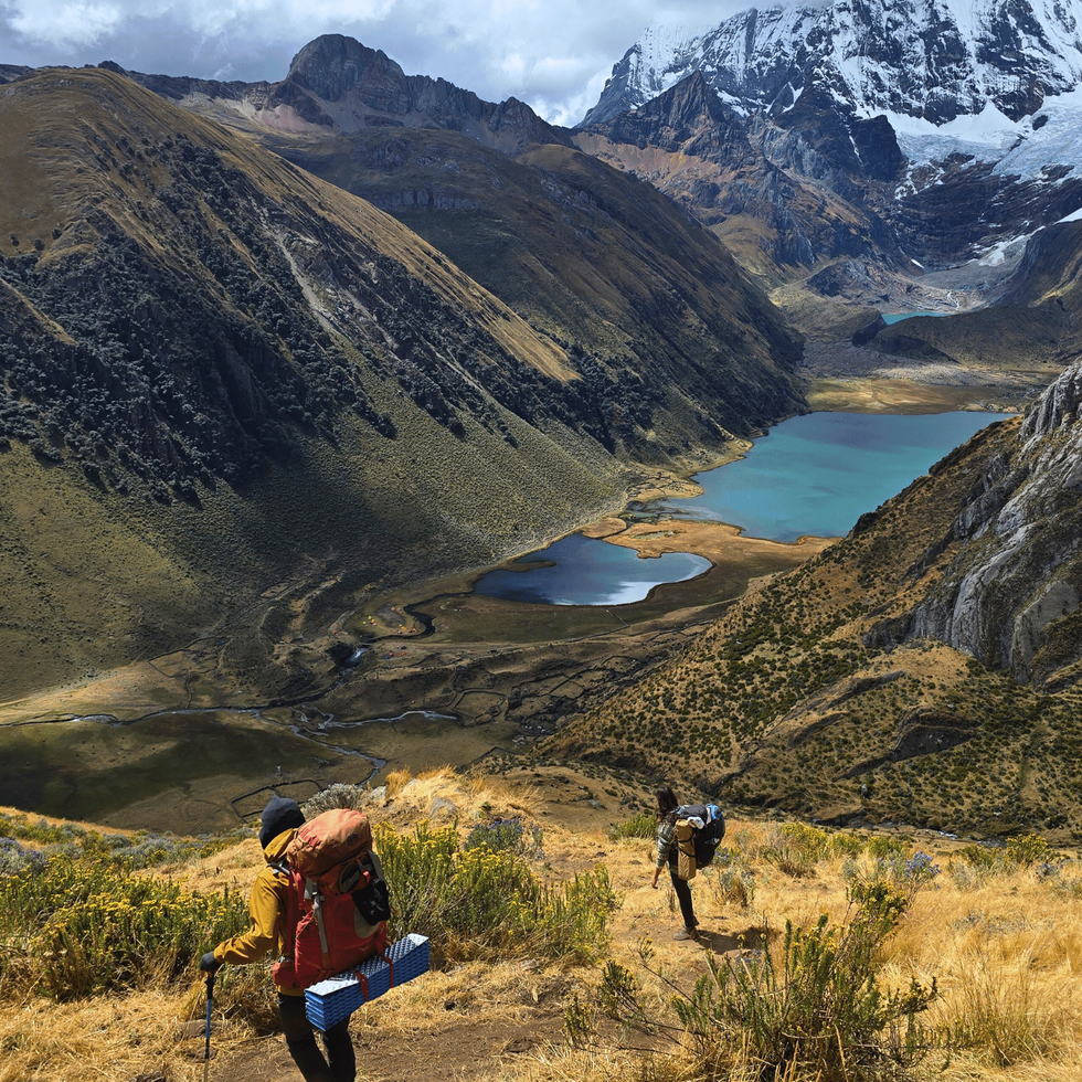
We had to walk a little higher to get ourselves into the trail, and pretty soon we were hit with an amazing vista of snow capped mountains and glaciers - we were so close to it!

You could tell immediately this wasn't a 'well-laid-path', and we were mostly navigating using cairns and sliding down skree (when we couldn't get onto the grippy rocks).
We move but further down and discover a huge do drop that we need to find our way down. Like, absolutely mammoth. But there is also a stunning lake, which is our destination - way down!!!
We take our time, and it's very slow moving! Arrive at more of a path again, skree rocks, and then enter a bull pen!! Kept moving, sidling the skree and we opt to camp down at the lake - with huge mountains and glaciers as a back drop! Beautiful.
We all went in for a quick dip, then preparing tea, and dinner.

Our tents pitched closely together.
After today, fourth day, biggest one yet - 9 hours on trail, and with the picturesque scene we have, we decide to walk it out to the village tomorrow. If we continued our original plan, it's another huge day, and a big back country pass.. our bodies are sore and tired, and we've already achieved so much!
Anyways, lying in bed, stoney floor bass, wind picking up a little... It's 7.10pm and I'm going to switch this is off and get some sleep!
Day 5 - Laguna Juraucocha to Huayllapa and beyond
Today, we had the option of another Alpine Route - more climbing, more intensity, or a slower, valley walk out to the Huayllapa Town... all three of us were completely exhausted, and the thought of another big day and climb wasn't enticing.
We decided to take the valley walk out, which felt really good - beautiful sunny day, we could take some layers off, enjoy a slower pace and enjoy the valley!
We ended up making this day a little more challenging at the end though...
Time on Trail - 10 hours
Main Route or Alpine Circuit - Variation Valley Route onto Main Route (after Huayllapa)
Elevation Gain - descending 900m but gained 400m at end
Total Distance - 18km
Highest Elevation - Laguna Juraucocha (where we stayed night before)
Campsite - wild camping just above Huayllapa (3,900m)
Tough sleep on the Stony ground, thankfully the wind didn't pick up any more. Absolutely stunning spot to wake up though. Lake, glacier and huge mountains right on our doorstep.

Breakfast and tea, and a fairly quick pack down - our systems are getting really good at this stage!
Katie will usually be up and boiling water first thing (water that I collected and filtered the night before), and hot tea and breaky usually gets me up and at it. Either dry off tent / sleeping bag if there's sun, otherwise do the nature toilet, sunblock, teeth, trekking clothes on, pack bag, and strap tent/sleeping mat on. Honestly feels like strapping surf boards to the roof of a car when I put the tent on. Whole process takes about 1.5 hours.

We left by 8.30am today, back tracked up the ridge we came down to find our campsite, and then trailed down the valley, along side the river.

We had an even more adventurous day planned, but based on how our bodies are feeling well decided to 'take it easy' with an 18km walk out to a village. Trail was really fun - so thankful not to be climbing all day. Lots of waterfalls, saw a few loads of donkeys heading up the valley (probably to setup a lunch service for the guided tourists).
We enjoyed lunch on a mini island, right next to the river. Katie jumps in for her daily plunge - get it girl.

Another hour or two and we hit the gate keepers - we initially walk straight past the lady who had her ticket book. Doesn't even say hello - first thing is 'pagar, pagar' - pay, pay! Rude!
We blitz it, and I'm thinking there's no way she'll catch up, but she's running and moves into her house along the trail and shouts something to her family - probably, 'lock the gate'!
A young man bolts out of the house, jumps a fence and runs ahead of us to lock the gate. Which is stone walled around us - feels like we're in jail. They're asking for 50soles EACH!
FOR WHAT!?!?
I get the feeling these people might 'own' that part of the land, so feel entitled to create a barricade and charge every tourist that passes through, without offering anything in return!
It's a good old fashioned stand off, and we're lucky again to have Alice, our 21 year old french girl, who is fluent in Spanish.
I take a photo and video of the bullshit, and we hold our ground. After 15 minutes or so, we negotiate it down to 50soles for all three, which is still a lot of money for a Peruvian. And still, for what are we paying??? We already paid our park entry fee... Feels criminal.

Anyways, wet get into the village and find someone to make us an egg, cheese and avocado sandwich. Even with a native speaker, it is incredibly difficult to figure this out. Price point and order took about 15 minutes, and she still got it wrong! She gave Katie and I 8 sandwiches, and we wanted 2 each.
Bless her heart - she was very sweet and welcoming, she gave us power for phones and wifi connection. So it was very helpful in the end.
We checked a few emails, and changed devices, and more importantly, checked the map.
700m climb to the next campsite!!!! And it was 4pm - fuck! After staying in a main campsite two nights earlier, we really wanted to be by ourselves, in nature, hearing the breeze and sound of the river. Not dogs barking and people everywhere. I come to respect this part more and more when I go on hikes!
So, after 7 hours of walking, with maybe 2 / 2.5 hours of light left in the day, we agree to walk back out of the town and start climbing!

We know we can't make the campsite, but looking at topo maps we see a couple of areas about half way that could work.
The climb is steeeep, and it's a very gnarly valley - zero chance of camping anywhere. It gets to about 545pm, and we peek into an area that could maybe work; grassy, but it's too step. We poke our heads around the corner a little more and see more steep grass, but with one tiny area that is suitable to pitch our tents. Last two nights we are literally right next to each other. Super lucky!!! Bit if a downhill lie, but manageable. Right next to the river.
I restock our water supplies after pitching tent. Katie isn't feeling well, so it's hot tea and straight into bed. I try get a fire going with Alice but not working.
Baby wipe shower, teeth and into bed!
All up, we walked 9 hours and still managed to climb about 400/500 metres! Golly.
But, it's better getting a head start on this one now - it's about 1,200 metres up totally from the village, up over the pass. Which is massive in one hit! We're almost halfway there :)
It's 8.08pm and I'm clocking out. Let's see what tomorrow brings - only two more nights, three more days on the Huayhuash.
Day 6 - Near Huayllapa to Near Gushpa
The long pass! Even though we had a head start, today felt like forever climbing up!
Time on Trail - 6 hours
Valley or Alpine Circuit - Main Route
Elevation Gain - 800m
Total Distance - 9km
Highest Elevation - Tapush Punta (4,770m)
Campsite - wild camping just past Gushpa (4,300m)
All went smoothly in our little campsite nook at the side of the hill. Up around 7am, and could see some people walking by above us, existing very brief glances through the trees.
I have a smoothie for breakfast, which I discover isn't quite enough for uphill walking. Starving again in a couple hours.

Anyways, on the trail by 820am - and it is straight up hill!!! We knocked out maybe 300/400m the afternoon before, but we have about 800m to climb. Up. Up. Up.
I soon need to stop and eat, and I chow down my left over egg/cheese sandwiches and a snack bar. Not ideal as I now need to get up and keep climbing - but the body is feeling lethargic. I'm slow for the next 30mins until the food digests a bit.

The steep uphill turns into a gradual climb; we pass a flock of sleep, donkeys running up the trail, a few dogs, guided trekkers sitting on the back of horses getting taken up the hill, some people mining something from the side of the hill, and finally, finally make it to the top, where we are greeted with some stunning views and a Laguna on the other side.
We stroll down to the Laguna edge to have a decent break and lunch, with the dutch couple.

The main campsite is set for the guided walkers, and we have no intention of staying here - were keen to see what's around the corner. We walk past the campsite, and notice a corner point where we see the 'community' members asking for money. The dutch couple, and french duo we just met have just gone through - paying 30soles each. The three of us just walk straight past them, and down the steep, rocky path out of there area.
By this stage, we know it's a territory thing, they don't have radios, no one is going to check our tickets... They do have horses tho, but I just don't see them coming down the path we just went down, and anyway, we're not staying in their site! If they attack us, what does that day about their desire to have travellers passing through... Anyways, we have 90soles total.
So far we've only paid on day 1 - 70soles, day 2 - 20soles, day 3 - 30 soles, day 5 - 17 soles. We're saving about $150 nzd.
We reach the bottom of the path, walk a little further and bag drop to decide next moves. It's 2.30pm ish - we can either climb over the next pass (another 400 ish metres), or find a freedom camp spot just under the pass. We decide to not push it to the extreme again, take rest and set up below the pass.
We have some great chats with the dutch couple, eat dinner and feel it snow/hail softly over our campsite. First time all trek we've had clouds or any sort of weather! Been very lucky, and from the radar it looks like we'll make it out fine in the next two days.

I can hear sounds of the river, it's 7.20pm - I've just been reading for an hour or so, and I'm probably going to call it a night. Let the body rest. Although, it's hard a sleep - my hips are so tender from the pack straps, the mat isn't that thick, and it's not the softest of ground. But hey, that's what happens when you're soaking up beautiful natural surroundings.
Night!
Day 6 - Near Gushpa Campsite to Llamac via Llaucha Pass
Two routes in one day! We made it to the campsite in decent time, and opted to try walk all the way out.

Time on Trail - 10 hours
Valley or Alpine Circuit - Alpine Route into Valley Exit Walk
Elevation Gain - 550m
Total Distance - 27km
Highest Elevation - Llaucha Punta (4,850m)
Exit - we finished in Llamac around 6pm (3,300m)
Our freedom camping spot turned out well! I was a little worried about the previous campsite 'community members' coming down and hassling us for money, but that never happened.
As with most days, we saw guided groups passing by nice and early (it's typical for a guided group to wake at 5am ish, with breakfast made for them and zero admin to do with camp pack down). It's still much more rewarding doing this admin yourself; the freedom of being 100% self-reliant is powerful.

Our day starts with a final climb to Tapush Punta at 4,770m. It's a steady climb, and not too intimidating as you can basically see the pass from the start of the day. We had mules and horses following us up most of the climb, with their loud yells and music blasting. Oh, the serenity!
Yet another stunning vista from the pass, with some clouds sprinkled over the mountains in the distance and a bit of cold wind at the top. We take the commonly walked alpine route to vista points of Lake Jahuacocha - an amazing scene from the top!

It's a mega steep elevation drop from the top point, all the way down to the Lake - very steep!
We slowly descend and make sure to avoid the Lake / campsite area (which is where we'd be charged again, for nothing). We instead find a really cute riverside lunch spot; time for another swim!

Sun is out and we enjoy lunch and the refreshing fresh water. Checking our maps we figure it's best to walk as close to Llamac as possible, and we see a final campsite near the end of the trail to aim for.
The final valley exit walk is super fun; quite narrow, with steep drops to the left and steep inclines to the right. Lots of landslides keep us guessing whether the entire trail will actually be open or not.

I'm walking in a singlet at this point, lower elevation and it's been a super sunny day, up until the dark clouds surround us and I feel specs of hail hitting the body. I stop to find my jacket and bag-rain-cover, and as I do it starts pounding down with hail! My Patagonia jacket is easy to find, but my bag cover I've put in a different spot and it takes me a good couple of minutes to find it! Ahhhhh !
We all get our bags covered and continue trekking out - at this stage, slightly wet, we opt to walk all the way out to Llamac, and using the little cell service we have, we start communicating with contacts in Huarez to find a ride back to Huarez the same night.
Our one driver contact in Huarez confirms with us that we can take a ride that same night from Llamac to Huarez, meeting at 6.30pm in Llamac.
We arrive in the little town, only to find that there are no rides leaving (as construction / closures happen on the main road at night), so we're stuck for a night - quite disappointing, as we would have just camped in the mountains knowing that.

We also found the Dutch couple who had already setup their campsite for the night at this beautiful spot, we can convinced them to packdown and come with us for the ride back to Huarez, only to find we couldn't, and had to pay for a night in a very remote town. Camping would have been much nicer. Although, a mattress was a nice respite for the bruised hips!
Anyway, we're out, we had a few egg/cheese sandwiches and have a 6am bus booked back to Huarez which we make, finally arriving back in Huarez by 11am.
That's us - 7 days on the Cordillera Huayhuash Circuit.
Fully unguided, self-reliant and thriving!

PACK LIST FOR CORDILLERA HUAYHUASH
Tent
Sleeping pad
Sleeping bag (-13°)
Silk liner (extra warmth)
Jet Boil
2x gas canisters (two ppl - careful of the brand, some cheap local canisters can clog)
Radix savoury dinner meals (Ultra range 800 -31.9g protein each)
Radix breakfasts (30.5g protein)
Radix smoothie packs (backup - 21g protein each)
Nothing naughty snack bar each day
Extra snack bars, nuts
Small snap lock of cashews, bliss balls and almonds (1x of each)
Head torch (w spare batteries)
Tea sachets, tumeric pills, vit c, electrolytes,
Spork
Micro towel
Sawyer filtration system for water
Bottle
Enamel mug
Kindle
Puffer jacket
Sunnies, sunblock
2x buffs
Boots / jandles
Satellite GPS for emergencies
3x merino socks (thin, medium, thick)
Compression shorts and longs
2x Merino underware
Hiking pants - zorali
Merino base layer
Merino singlet base
Merino mid base/mid layer
Merino long johns icebreaker
Merino beanie
Merino t shirt
Gloves
Shorts
Long sleeve shirt (light weight for sun protection)
First aid kit (with plasters, Panadol, knife)
Rain jacket
Coka leaves / tea mix
Go Pro
Nitecore 10,000 battery pack (cables)
Rain protection for bag
Large dry bag
Plenty of cash 400 / 500 soles (have small notes for campsite fees)


